Deskripsi
Deskripsi
GPS Geodetic / GNSS Hi-Target IRTK 5 (Global Navigation Satellite System) yaitu teknologi yang digunakan untuk menentukan posisi suatu objek di permukaan bumi menggunakan sinyal satelit. GNSS menjadi sangat penting dalam berbagai aplikasi seperti navigasi, pemetaan, survei, pemantauan pergerakan tanah, dan sebagainya.
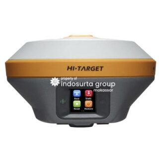
Salah satu produk GNSS terkini adalah Hitarget IRTK 5, yang menawarkan teknologi pengukuran posisi yang sangat akurat. GPS Geodetic/GNSS Hi-Target IRTK 5 di rancang untuk memberikan hasil pengukuran yang akurat bahkan dalam kondisi lingkungan yang paling sulit, seperti di area perkotaan yang padat atau di daerah pegunungan yang terjal.
IRTK5 juga dilengkapi dengan fitur-fitur canggih seperti pembacaan sinyal multi-GNSS, yang memungkinkan sistem untuk menerima sinyal dari banyak sistem GNSS seperti GPS, GLONASS, Galileo, dan BeiDou. Hal ini memastikan bahwa sistem selalu memiliki akses ke sinyal GNSS yang paling kuat dan dapat memberikan hasil pengukuran yang lebih akurat.
Beli juga : Total Station Sokkia IM-52
Selain itu, GPS Geodetic/GNSS Hi-Target IRTK 5 juga dilengkapi dengan sistem pemantauan kondisi lingkungan secara real-time, seperti suhu, kelembaban, dan tekanan atmosfer, sehingga pengguna dapat memantau pengaruh lingkungan terhadap hasil pengukuran.
IRTK5 juga di lengkapi dengan layar sentuh berwarna yang mudah digunakan, sehingga pengguna dapat mengoperasikan sistem dengan mudah dan cepat.
IRTK5 dapat di gunakan dalam berbagai aplikasi seperti survei, pemetaan, dan konstruksi. Misalnya, dalam industri konstruksi, IRTK5 dapat digunakan untuk memastikan bahwa proyek bangunan berada pada posisi yang tepat dan sesuai dengan rencana, sementara dalam aplikasi survei, IRTK5 dapat digunakan untuk membuat peta yang sangat akurat dan rinci.
Spesifikasi GPS Geodetik/GNSS Hi-Target iRTK 5
Satellite Signals Tracked Simultaneously
- Channels: 1408
- GPS: L1C/A,L2E,L2C,L5
- BeiDou: B1, B2, B3
- GLONASS: L1C/A, L1P, L2C/A, L3 CDMA
- Galileo: E1, E5A, E5AltBOC, E6
- IRNSS: L5
- SBAS: L1C/A, L5(QZSS, WAAS, MSAS, GAGAN)
- Global correction service: Hi-RTP/RTX (optional)
Positioning Performance
- High Precision Static
- Horizontal: 2.5 mm + o.1 ppm RMS
- Vertical: 3.5 mm + 0.4 ppm RMS
- High Precision Static
- Static and Fast Static
- Horizontal: 2.5 mm + 0.5 ppm RMS
- Vertical: 5 mm + 0.5 ppm RMS
- Static and Fast Static
- Post Processing Kinematic (PPK / Stop & Go)
- Horizontal: 8mm + 1 ppm RMS
- Vertical: 15mm + 1 ppm RMS
- Initialization time: typical 10 min for base and 5 min for rover
- Initialization reliability: typically > 99.9%
- Post Processing Kinematic (PPK / Stop & Go)
- Code Differential GNSS Positioning
- Horizontal: 25 cm RMS
- Vertical: 50 cm RMS
- SBAS: 0.5 m(H), 0.85 m(V)
- Code Differential GNSS Positioning
- Autonomous
- Horizontal: 1 m RMS
- Vertical: 1.5 m RMS
- Autonomous
Real Time Kinematic (RTK)
- Single Baseline
- Horizontal: 8mm + 1ppm RMS
- Vertical: 15mm + 1ppm RMS
- Single Baseline
- Network RTK (VRS,FKP,MAC)
- Horizontal: 8mm + 0.5ppm RMS
- Vertical: 15mm + 0.5ppm RMS
- Initialization time: typically 2-10s
- Initialization reliability: Typically > 99.99%
- Network RTK (VRS,FKP,MAC)
- Hi-Fix
- Horizontal: RTK + 10 mm/minute RMS
- Vertical: RTK + 20 mm/minute RMS
- Hi-Fix
- Tilt Survey Performance
- Additional horizontal pole-tilt uncertainty typically less than 10 mm +0.7 mm / °tilt (2cm accuracy in the inclination of 30 under good condition)
- Tilt Survey Performance
Hardware
- Physical
- Dimension (W x H): 158mm x 98mm (6.22 inch x 3.86 inch)
- Weight: lighter than 1.3kg (2.65lb) within internal battery
- Operation temperature: -40°C ~+ 75°C ( -40°F ~+ 167°F )
- Storage temperature: -50°C ~+ 85°C ( -58°F ~+ 185°F )
- Temperature control: Auto-adjust the working power to maintain the temperature
- Humidity: 100%, condensing
- Water/dustproof: IP67 dustproof, protected from temporary immersion to depth of 1m (3.28ft)
- Shock and Vibration: MIL-STD-810G, 514.6
- Anti-salt spray: MIL-810G, 509.4, 96h
- free fall: MIL-STD-810G, 516.6, designed to survive a 2m(6.56ft) natural fall onto concrete.
- Physical
- Electrical
- 6V to 28V DC external power input(5-pin port), with over-discharge protection power consumption 4.4W Automatic switching between internal power and external power.
- Electrical
- Control Panel
- Physical button: 1
- Display: 240 x 240 pixel, 261 ppi
- Touchscreen: Support glove mode and wet-finger mode.
- Control Panel
- Internal Battery
- 7.4 V, 6800 mAh lithium-ion rechargeable and removable battery.
- RTK rover(UHF/Cellular) for 10 hours.
- Power indicator embedded.
- Quick charger within 3.5 hours.
- Internal Battery
- I/O interface
- Bluetooth 4.0/2.1+ EDR, 2.4 GHz. USB 3.0 port, OTG function. 1 SMA antenna connector.
- 1 DC Power input(5-pin), 1 SIM Card slot.
- Near Field Communication(NFC).
- I/O interface
Communication
- Network Communication
- Full band support for cellular mobile network(LTE, WCDMA, EDGE, GPRS, GSM).
- 2.4GHz Wi-Fi, supports the standard protocol 802.11 b/g/n. Network RTK(in CORS) range is 20-50km
- Network Communication
- Internal UHF Transceiver Radio
- Frequency: 403~473MHz
- Transmitting power: 1~4W Hi-Target Advanced Radio
- Support Protocols: Hi-Target, TRIMTALK450S, TRIMMARK III, SATEL-3AS, TRANSEOT, etc.
- Working Range: Typically 3~5km, optimal 5~8km.
- Internal UHF Transceiver Radio
- External UHF Radio
- Frequency: 410~470MHz.
- Transmitting power: 5W / 25W.
- Compatible with third party radio.
- Working Range: Typically 8~10km, optimal 15~20km.
- External UHF Radio
System Configuration
- System
- Data Storage: Circulating 16GB Internal storage Record GNS and RINEX format simultaneously.
- System
- Data Formats
- 1Hz positioning output, up to 50Hz. CMR, CMR+, RTCM2.X, RTCM3.0, RTCM3.1,RTCM3.2. Navigation Output ASCII: NMEA-0183 GSV, AVR, RMC, HDT, VGK, VHD, ROT, GGK, GGA, GSA, ZDA, VTG, GST, PJT, PJK, BPQ, GLL, GRS, GBS. Binary: Trimble GSOF, NMEA2000.
- Data Formats
Kelebihan beli GPS Geodetic di Indosurta Makassar
- Bergaransi servis 1 tahun
- Gratis training alat
- Gratis pengiriman dan juga COD khusus Makassar dan sekitarnya
Video dari Indosurta